We were sitting on the porch this morning having our coffee, awaiting the dawn. Reminded me of an old Charlie Daniel's Band song.."High Lonesome" in some ways. "Just you and me and a little white pup, sitting here waiting for the sun to come up...."

(sorry for the grainy blur...there's not much light yet at this time of day. But oh, there will be, later)
We decided that we will grab this weather window and boat over to Pine Cay this morning. The first house guests of the season are arriving there next Saturday, and we want to make sure the house is ready. All the window cranks work, that the new refrigerator was delivered and installed and is working and the ice trays are filled. I will adjust all the rollers on the sliding screen doors, and make sure all the screens are intact. Just generally making sure everything in the house works so that their vacation is as smooth as we can make our part of it. They are family friends, and very interesting people, but that's another story.
We will take the 'back way' over the Bank this morning, instead of our usual trip through Leeward and up the outside. Its kind of tricky, involving a lot of little solid rock islands, shifting sand bars, shallow channels, and skinny water. Its shorter than going through Leeward by about a mile, but in the past we have tended to avoid it except in bad weather. We have never done it at night. But now that we no longer will be stopping in Leeward for fuel, or to catch up with friends hanging around the dock, its a good time to learn this route like the back of my hand. I suspect we will be using it more and more as time goes on and things get congested in our old stomping ground. But if you are ever going to run aground down here, this is a real good route to take to increase the chances of that experience.
Its also the route the locals use more than any other. Its the most direct route from Provo to the settlements on North and Middle Caicos, and also to the town on South Caicos. The hotel excursion and dive boats, and the Parrot Cay boats don't typically go this way, they draw too much water. Any boat that draws more than three feet, max, should definitely avoid this route. Even a two foot draft should run it only at high tide.
So, we should be able to get some photos of that side that we haven't posted before. Will be more of the same, I am afraid, little islands and shallow, crystal clear water. Could be worse.
We did make the Pine Cay trip this morning. We got a fairly early start ( for us) and were back by mid-afternoon. We took a little over a hundred photos, so I will pick some out to post.
I know I have mentioned the roads here. Why we drive little 4x4s. The road to our house site is over 3 miles of rutted rock and loose gravel after leaving the pavement. The road to the marina is worse. Here are some examples:
This section gets treacherous when its raining. The sand washes out of the ruts cut into the rock. Last month a lawyer was heading home after celebrating a court case he won on behalf of Beaches employees, and he hit these very ruts in his jeep, lost it, slammed into a little cliff without wearing a seatbelt, and he died. That was while we were in Massachusetts visiting.

This is supposed to be two lane here. Its wide enough, but everyone drives on the more packed side, of course:

A couple miles of this stuff, then a little turnoff, and over a hump:

across a dirt parking lot, then we are at the boat. We drove the boat here on its trailer one time, the day we launched it back in early April. It has been in the water since then. And the trailer is at the boatyard. Someone on THT had asked me why I didn't trailer the boat. I think this might give you an idea why we like to leave it in the water.
We clear the marina, and head toward Leeward. To take this route, I have found that if I just steer 060 deg. magnetic, for about 9.4 miles, we come to one of the TCI's well established, aids to navigation installations:

When we first got here, this spot was marked with a 55 gallon drum impaled on a piece of 4" PVC driven into the bottom. The steel drum is long gone, of course, but people come by here and hang buoys, or stick something in the sand to mark this point. If you go thirty yards beyond this, you are probably going to be hard aground. The good news is that if you radio someone and tell them you are here, they will know exactly where you are.
And no, there's no numbers, no bells, no radar reflector, no light. Its not on any chart. Its not maintained by the Coast Guard. Its just, well, what you see.
Welcome to our world.
From this point, you are about two miles almost due South from the entrance to Pine Cay cut, but there are maybe a dozen small rock cays in the way. This last two miles is the reason we haven't run this trip in the dark yet. Today I left a dotted line on the GPS though. If I remember to save it as a route, I should be able to do it some night. If I have to.
We did the repairs to the screens at the house on Pine Cay. I had to fix 8 screens, and the frozen up rollers for two sliding doors. In packing things up, we had to make a sad decision. The Texas flag, which I have been flying every time we were at the house there, has now been officially retired from active duty. I think if you take a look at it, you will see why:

I admit, it grieves me greatly to know that I won't be flying the Lone Star down here until I can someday get a new one, but I just could not, in good conscience, run this tired banner up another time. I will find a place of honor for it inside the new house somewhere, of course. And I will be able to tell people truthfully that this flag has been proudly flown over foreign territory in a previous century. Its a Texas thing, some of you will understand.
After re splining the 8 screens, pressure washing them, and catching up on some other maintenance, we headed back. It was still early in the day, but the weather was beginning to make some not-so-subtle threats in the form of approaching squalls and lightning bolts. The dog was the first to notice the weather turning bad.

He communicates his concerns quite effectively. He huddles in the corner, shivering, and panting. Or he gets underfoot and trips us, but he makes his feelings known.
By the time we loaded up and headed back to the boat, it was getting "iffy" as to whether we would outrun this one. Here's a shot of Main Street, Pine Cay, by the way:

The squall line had begun to close in on us as we loaded up the boat. The dog would have been saying rosaries if he could have stopped shaking long enough. Oh, and of course, if he was Catholic. He may be. We've never discussed it.

This one was already dumping rain just about a half mile away, so our trip got cut short. We had to get out and west of here if we wanted to get back to good weather. La Gringa managed to get some pretty good photos on the way back. I am going to post these now, because I have been having some internet glitches. I will post the others in a few minutes.
Coming out of Pine Cay cut, the first marker is this little bitty, solid, piece of limestone. Marked with a piece of PVC pipe, of course:

We want to end up between two of those islands way behind it, on the left. But you can't just head there in a straight line. Well, I guess you could, but you wouldn't make it. So you head for this one, then turn a hard left ( port for you nautical sticklers) and head for this one:

but you don't go all the way to it, you turn right again about half way there. And you ignore that weather, yer committed now anyhow.
And this is starting to look like a REAL good time to be making right turns....

And you head right at this one, and veer away left again before you hit it. You won't veer anywhere, if you hit it.

Ok, we made the left. Where we want to end up is about a half mile off that far point to the left of center of the photo. But we can't just go straight there. Oh no. NO no no no no. Don't go between the rocks. Bad idea. Gotta hook around the last little cay in the photo there on the left:

and once you are clear of this last little bad boy...

You are free to swing gently back round to the right, to the reciprocal of the 060 deg. you used running up here ( 240 to save ya the math)
and you can open up the throttle a bit, let the engine back down to half way on the jackplate, and bring the tabs back up.

And on a day like today, that puts this stuff right where I like to see it....behind the wake.
Ok, I left out a couple turns, but I wanted to show how come we haven't run this part at night yet. you get the idea. No lights no buoys, no reflectors, no markers, just these wicked little rocks sticking out of the water in the most inconvenient places. Lots of them.
After this we pretty much booked it on down to Provo at a comfy cruise. GPS info in this area is typical, by the way:

Its hard to read, La Gringa was bouncing around a little, but it says one of the two things we see most on the GPS on the banks. This one says Unsurveyed".
The other one we see a lot says "Numerous Coral Heads".
Once we are past Bird Rock, we are back offshore Provo, and it's pretty familiar water to us.

We usually run the straightest line we can run from this point back to the marina. But this time, since we were easily ahead of the squalls, we took our time and putt putted down close to the shoreline. I will go through those photos and post them next.
After we got back down to the island of Providenciales (Provo) we decided to cruise slowly, this time, and check out the shoreline. We usually zip past all this about a mile offshore. But now we are starting to pay more attention to the part of the TCI that will be our immediate neighborhood when we move into the new house in a couple months.
There are many, many more scenes like this. There must be literally hundreds of small caves along this stretch of Provo:

Looking over the side of the boat, the water isn't as calm as it was last week, but the clarity is still there. This is in six feet of water:

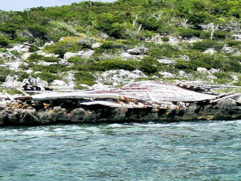
Down the beach a ways, we went by this Haitian sloop foundered on the rocks in a fairly remote part of the island.. This one made it all the way to shore with it's load of refugees. They typically put something like 75 to 100 people on these little badly made sloops. They have them crowded down in the hull, and the decks totally covered with people with their little bags and backpacks of belongings, clinging to each other in fear and hope.

Can you imagine how it must sound on a pitch-black night when one of these boats makes it through all the perils and finally comes ashore? Always at night, the scariest and darkest hours before dawn on a night with no moon, and with clouds if possible. The sounds of a hundred voices calling out in the darkness, people terrified and yet knowing they need to keep moving, keep quiet, hide? People speaking Creole, and some Spanish, and afraid because the boat is hitting rocks, and leaning over as the keel starts dragging, dumping many of them into the unknown water in the dark. And they must go into the water, climb ashore, and hide. They have been sailing all the previous day, and all that night, with no shelter from the sun, no fresh water, no food, to travel the 140 miles from Haiti to this beach. There's no doubt they have been bailing the boat the whole time. Many are seasick. No bathrooms on board for a hundred men and women. A surprising number of them cannot swim, as we have sadly learned. The chances are excellent that they will be caught at sea by the Maritime Patrol, towed to South Dock, put into a detention center, and then in a few days, flown back to Haiti. A few months ago 65 of them died when one of these boats flipped over in a storm off of Provo. Getting arrested is also not totally safe, last week three of them died from dehydration in the detention center.
They keep coming, though. And these boats are knocked together from scrap lumber, they only need to make one trip because they are either going to be impounded and destroyed by the Police, or they are going to hit the rocks and just stay there until they break up, or they are going to sink. This one made it to shore.
I think about the noise of it all, how it must sound. And then I think about all these desperate people hitting landfall just a couple hundred feet from the bedroom window in the middle of the night. Hows THAT for a wake-up call?

What do you think...are you ready for a hundred tired, wet, hungry, unexpected guests who don't speak English waking you up at four AM? Can you handle breakfast for say, 85, on short notice? Some are gonna want seconds...
almost makes one wish for a McDonald's down the road.
People in the homes along this stretch of beach say that the Haitians knock on the door, and ask if they can spare any food, or water. Sometimes they ask if a few of them can get a ride into town to contact their relatives, while the rest hide in the bushes. We haven't heard of any home break ins, nor any violence by the refugees against people living in homes here. Of course it's illegal to help them or give them a ride. You are supposed to call the Immigration people. Maybe I shouldn't tell you that La Gringa and I gave three guys a ride to town one morning...when we had been out to the house site.
This is still one of the relatively undeveloped parts of Provo, similar to where we are building. There are an increasing number of newer homes on one acre waterfront lots:

not too shabby, I think.

To live on this side, you give up the sandy beaches and the dramatic waves breaking out on the reef. You also give up the resorts, the blocks of condos, traffic, paved roads, convenience stores. You trade that for peaceful clear water right up to the rocks, unbelievable amounts of conch, mutton snapper. You get some elbow room, some quiet. You get sunrises from the ocean on the left, and sunsets to the right when you are looking out over the Bank. This is the side we chose.
They are a little bleak and exposed looking when first built:

but a little landscaping starts making a difference pretty quickly:

And with a steady supply of fresh water irrigation and some time, it really starts turning into something nice:

We really like the turret-shaped patio these guys built off away from the house. It must be a nice place to sit and watch the ocean.
Starting to get closer to our new neighborhood now..


While travelling along, we did spot wreckage of at least three more Haitian sloops, such as this one:
We are pretty sure this is part of whats left of the sloop photo I posted a month or so ago. It broke up, and this drifted in.
And this one:

We also passed several areas where nice big pieces, well HUGE pieces, of ocean cleaned, polished, and cured driftwood collect. We can just drop the hook, wade ashore, and pull them back to the boat. Its all tropical hardwood. I sure know where I am going to go shopping for weathered boards and driftwood once I get my shop up and running. I have some ideas for the boards from the sloops already, and have a driftwood tree in mind for a hammock stand.
We thought a lot about storm surges and hurricane waves when looking at building lots. The good thing about being on this side of the island is that the Caicos Bank extends outward from those lots a distance from 18 miles to the reef drop-off at the closest point, to over 30 miles to the southeast. It's got an average depth of probably something around 10 feet for most of it. That expanse of shallow water is going to naturally limit wave height at the shoreline. Waves just cant get that big in ten feet, or less, of water. It doesnt get ten feet deep in front of those houses until you get almost two miles out. They are sitting roughly eight to ten feet above sea level. I think they will be okay,except in the most extreme hurricane. Those houses I just posted photos of are in much better locations than many I could show you.
Having said that, the last really serious hurricane to hit these islands was almost fifty years ago. It's long overdue, statistically speaking. During that storm, Hurricane Donna, 1960, there was very little in the way of manmade construction on Provo. The population of the whole island was maybe 300 people. And those were native people, like our best friends here, the Stubbs family. They knew enough to build their homes inland, and on higher ground. There were a few dozen houses here, at most, in those days. Not much here for a storm to tear up. And nobody much to notice if it did. No highways, electricity, just some docks. Very simple lifestyle then.
Now, it's all different. It's all built up by people who have never been in a hurricane. My feeling is that the next major storm to hit here is going to cause massive water damage to a lot of properties that have sprung up right on the water. The winds are going to point out any building mistakes or shortcomings in the multistory hotel designs. The houses are built from steel reinforced concrete, and the walls will probably withstand the wind even if the windows and roof let go. But the power of the ocean, well, I think a lot of people just either dont realize what can happen, or they have chosen to take the gamble. It's all still academic to most of the owners of these homes, and many of them are vacant vacation homes during hurricane season.
We built on this side of the island, but the floor of our house is almost 60 ft. above sea level. Maybe I am getting more cautious in my old age, but we chose that site with that as one of the criteria, height. of course it also helps the view, and the breeze. We do have to walk across the road to climb in the water. We didnt see that as being a huge drawback living here full time, since no place on the island is farther than a mile or so from the ocean. Theres PLENTY of beach. Besides, we boat to remote beaches when we want to play in the sand. We have almost come to think that living on the beach is for people who dont have boats.
I think the houses on the beach, and the canal lots especially, on the other side of the island are going to be more affected by storm surge. Many of those are built with a lot of fill, and are maybe six feet above sea level. And they are closer to deep water. the reef comes to within a quarter mile of the beach in places, and its five thousand feet deep just on the other side. And the water between the reef and the beach is 20 ft. deep over there....well, you can see what could happen. The terrain also slopes at a shallow angle on the other side. This side has this natural rock barrier, the edges might crumble off, but the rock isnt going to wash away. It's also not going to flood,either from rain, nor from storm surge.
At least, thats our thinking on it. We intend to be in that house during the next hurricane, so we tried to think it through pretty carefully. If we can just scrape through this season unscathed, until the house is built, the generator is installed, etc. we should be okay going forward.
No comments:
Post a Comment